Infrastructure is not exactly the sexiest word in architecture. There are no “starchitects” proudly boasting about their pipe designs or subsurface drainage systems. By its very definition – the underlying structures that support our systems – infrastructure is inherently hidden from us, and therefore often overlooked. But without it our current cities couldn’t possibly exist. Without finding ways to improve it, our future cities will struggle to survive.
Showing posts with label Urban Planning. Show all posts
Thursday, 25 September 2014
Thursday, 14 August 2014
Can Subiaco cope with the loss of the Subiaco markets? Can I cope?
Non-investigative reporter Noah McDonald goes deep under cover to uncover the shocking truth!
The iconic Subiaco markets site is seemingly destined for redevelopment with reports a proposal for a four-storey complex that will include 4,850 square metres of office space is due to be lodged with the Metropolitan Redevelopment Authority in the near future. Now of course re-development is the property owners right, and of course such a proposal is entirely sensible for an owner seeking to realise the development potential of a property within a redevelopment area, BUT, what about me and my needs?!
Thursday, 3 July 2014
How Do You Move an Entire City? Ask Sweden
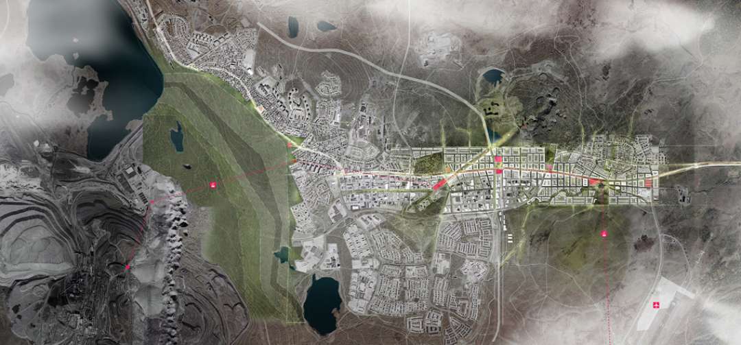
Northern Sweden may be most readily associated with the residential domain of Christmas-time characters, but the region is now turning fantasy into the future of sustainable urban planning — by moving an entire city of 18,200 people two miles east of its current location. Kiruna, founded in 1900, is an iron ore company town and home to the iconic Icehotel, but is slowly cannibalizing upon itself. As the ground beneath the city’s western edge has been mined, deformation is encroaching on the city’s very bedrock.
Monday, 16 June 2014
How to Design a City for Women
In 1999, officials in Vienna, Austria, asked residents of the city's ninth district how often and why they used public transportation. "Most of the men filled out the questionnaire in less than five minutes," says Ursula Bauer, one of the city administrators tasked with carrying out the survey. "But the women couldn't stop writing."
Women used public transit more often and made more trips on foot than men. They were also more likely to split their time between work and family commitments like taking care of children and elderly parents. Recognizing this, city planners drafted a plan to improve pedestrian mobility and access to public transit.
Additional lighting was added to make walking at night safer for women. Sidewalks were widened so pedestrians could navigate narrow streets. And a massive staircase with a ramp running through the middle was installed near a major intersection to make crossing easier for people with strollers and individuals using a walker or a wheelchair.
Women used public transit more often and made more trips on foot than men. They were also more likely to split their time between work and family commitments like taking care of children and elderly parents. Recognizing this, city planners drafted a plan to improve pedestrian mobility and access to public transit.
Additional lighting was added to make walking at night safer for women. Sidewalks were widened so pedestrians could navigate narrow streets. And a massive staircase with a ramp running through the middle was installed near a major intersection to make crossing easier for people with strollers and individuals using a walker or a wheelchair.
Sunday, 30 March 2014
Cities Are Like Elephants: They Get More Economical With Size
Cities have long been compared to
organisms—Plato talked about the city as a corporeal body, and the urban spaces
we’ve created have come to resemble their creators. Structurally, they follow a
distinctly biological design and obey the same metabolic laws that govern every
organism.
Below the skin and under the street
lie the intestines, the metal intestines that allow suburbs to sprawl and
skyscrapers to rise. The fiber-optic cables are nerves, and the subway tunnels
are thick jugular veins. Energy is distributed, and waste is digested. All this
generates a sort of animal heat, which escapes from the grates in the gutters.
The foul steam is exhaled breath. But how true is this metaphor? Are cities
really like living things?
A team of physicists and economists
led by Geoffrey West of the Santa Fe Institute recently set out to answer these
questions. It turns out that, in many respects, cities act just like creatures.
They obey the same metabolic laws that govern every organism. Their
infrastructure follows a distinctly biological design, which helps explain why
cities are able to grow.
Read more here
Wednesday, 12 February 2014
What's your Future City?
Check out the BMW Guggenheim Lab’s Urbanology game
The game seeks to teach players something about urban sustainability by asking them to give “yes” or “no” answers to a series of urban policy questions. It then produces some quick-and-dirty findings about the governing values implied by the answers, and identifies a real city that best matches those values. The eight values at issue are Affordability, Health, Innovation, Lifestyle, Livability, Sustainability, Transportation, and Wealth. Questions include items such as “Will you double the cost of public transport to fund its conversion to a carbon-neutral system?” or “Will you pay for a free bike service in your city”? Working with such yes/no dichotomies is not ideal, but it’s also not unreasonable as a starting point for conversation.
Wednesday, 23 October 2013
A Terrifying, Fascinating Timelapse of 30 Years of Human Impact on Earth
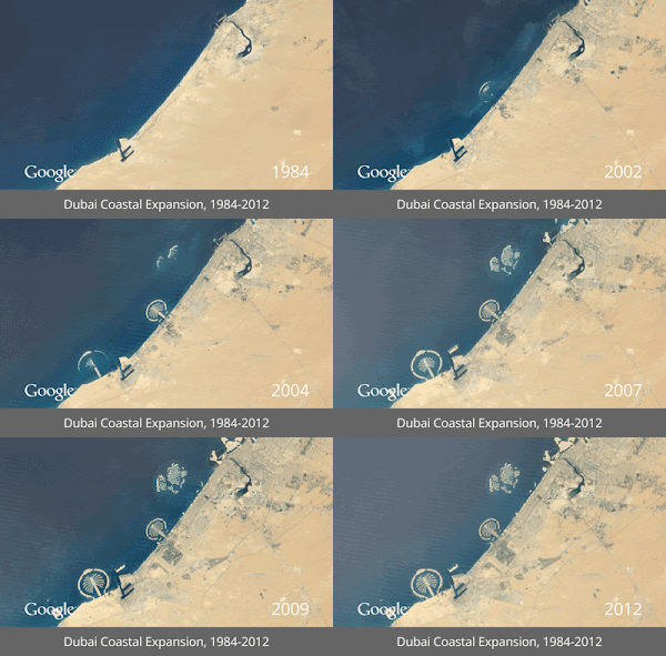
Since the 1970s, NASA and the U.S. Geological Survey have been amassing satellite images of every inch of our planet as part of the Landsat program. Over time, the images reveal a record of change: of cities expanding, lakes and forests disappearing, new islands emerging from the sea off the coast of rising Middle East metropolises like Dubai.
If you could thumb through these historic pictures as if in a flip book, they would show stunning change across the earth's surface, in both our natural environments and our man-made ones. Now, the digital equivalent of that experience is possible – three decades of global change as a GIF – in a project between NASA, the USGS, TIME, Google, and the CREATE Lab at Carnegie Mellon University.
Landsat images taken between 1984 and 2012 have been converted into a seamless, navigable animation built from millions of satellite photos.
Follow the link to a few of the GIFs Google has created showing some of the most startling pockets of change - LINK
If you could thumb through these historic pictures as if in a flip book, they would show stunning change across the earth's surface, in both our natural environments and our man-made ones. Now, the digital equivalent of that experience is possible – three decades of global change as a GIF – in a project between NASA, the USGS, TIME, Google, and the CREATE Lab at Carnegie Mellon University.
Landsat images taken between 1984 and 2012 have been converted into a seamless, navigable animation built from millions of satellite photos.
Follow the link to a few of the GIFs Google has created showing some of the most startling pockets of change - LINK
Friday, 27 September 2013
How to Design a City for Women
Don’t worry this is
not about separating the genders, or some post feminist ranty power grab.
In 1999, officials in Vienna, Austria, asked residents of the city's ninth district how often and why they used public transportation. "Most of the men filled out the questionnaire in less than five minutes," says Ursula Bauer, one of the city administrators tasked with carrying out the survey. "But the women couldn't stop writing."
The majority of men reported using either a car or public transit twice a day -- to go to work in the morning and come home at night. Women, on the other hand, used the city’s network of sidewalks, bus routes, subway lines and streetcars more frequently and for a myriad reasons.
"The women had a much more varied pattern of movement," Bauer recalls. "They were writing things like, 'I take my kids to the doctor some mornings, then bring them to school before I go to work. Later, I help my mother buy groceries and bring my kids home on the metro.'"
Women used public transit more often and made more trips on foot than men. They were also more likely to split their time between work and family commitments like taking care of children and elderly parents. Recognizing this, city planners drafted a plan to improve pedestrian mobility and access to public transit.
Read more at Atlantic Cities - Link
In 1999, officials in Vienna, Austria, asked residents of the city's ninth district how often and why they used public transportation. "Most of the men filled out the questionnaire in less than five minutes," says Ursula Bauer, one of the city administrators tasked with carrying out the survey. "But the women couldn't stop writing."
The majority of men reported using either a car or public transit twice a day -- to go to work in the morning and come home at night. Women, on the other hand, used the city’s network of sidewalks, bus routes, subway lines and streetcars more frequently and for a myriad reasons.
"The women had a much more varied pattern of movement," Bauer recalls. "They were writing things like, 'I take my kids to the doctor some mornings, then bring them to school before I go to work. Later, I help my mother buy groceries and bring my kids home on the metro.'"
Women used public transit more often and made more trips on foot than men. They were also more likely to split their time between work and family commitments like taking care of children and elderly parents. Recognizing this, city planners drafted a plan to improve pedestrian mobility and access to public transit.
Read more at Atlantic Cities - Link
Thursday, 5 September 2013
Book Recommendation
Made in Australia: The Future of Australian Cities
By Richard Weller and Julian Bolleter
How do you creatively plan for a population of 62 million by
2100? Australia’s current major city planning frameworks only account for an additional
5.5 million people. Whether we want a ‘Big Australia’ or not, Australia’s 21st
century is likely to see rapid and continual growth — and if we want liveable,
high functioning cities and regional centres we need to think outside the box.
Richard Weller and Julian Bolleter (from the Australian
Urban Design Research Centre) offer optimistic and creative solutions for the
future with one imperative: what we build this century will make or break our
country. The authors explore where these people might live so that Australia
remains ecologically resilient, socially amenable and economically productive.
- Part 1 – Big Cities, Big Ideas, Big Australia: Australia; Visionary Cities; and Visionary Infrastructure.
- Part 2 – Australian Cities 2012–56: Sydney; Brisbane and SEQ; Melbourne; Perth; Adelaide; Canberra; Hobart; Darwin; and Growing Pains.
- Part 3 – Australian Cities 2101?: Australian Megaregions and New Cities; The East Coast Megaregion (ECM); The West Coast Megaregion (WCM); and Darwin – The New North.
- Part 4 – Essays: Living with the Land; Back to the Future; Urban Resilience & Adaptation; Urban Metabolism: A way to make Australian cities more efficient?; Infrastructure: Now and then; New Settlements on the Fringe: Understanding contemporary peri-urbanisation; And now for the good news…; Cities as Water Catchments; Coding the City; and Follow the Money.
- Part 5 – Designs: Boyd’s Error: Planning’s curse; Infill Precincts; Mean Streets; A National Green Network for Australia.
Buy it now from Amazon
Friday, 16 August 2013
Urban Planning and the Christchurch Recovery
“To hell with resilience, more action, please.”
These words of a disgruntled, uncited local have restrained
me from writing an anticipated article on Christchurch’s ‘urban resilience’.
While resilience might well be urbanism’s most prevalent buzzword since
‘sustainability’ itself, I feel I must honour the above-quoted, unnamed radio
personality who rhetorically asked: “can we please stop patronising people by
gushing about their resilience?”
Indeed Cantabrians, being those who hail from the Canterbury
region in which Christchurch City is located, dealt and are dealing with the earthquakes
of 2010 to present remarkably well. But people are resilient. It’s what we do. Notwithstanding
how fantastically adaptable humans are, this article instead considers the
positive urban planning outcomes which have come out of Christchurch’s
preliminary recovery.
Monday, 25 March 2013
How Urban Planning Created Hip-Hop
I know what you’re thinking right, ‘Alex, you is cray!’, and you could be right, but you must also be thinking ‘Hey Maybe planning does have some street cred’.
This story begins in the most unlikely of places, not the South Bronx Projects but in 1920s Paris. The true godfather of hip-hop monsieur Charles-Édouard Jeanneret, better known by his street name as Le Corbusier. The first of his grand urban releases was the Ville Contemporaine in 1922, which like many of the early hip-hop artists, caused a great amount of controversy. Now what does he have to do with hip-hop you ask?
Labels:
Biggie,
Busta Rythmes,
Ghostface Killah,
Grandmaster Flash,
hip-hop,
Jay-Z,
Kool Herc,
Le Corbusier,
Method Man,
Mos Def,
New York,
South Bronx,
Supremes,
Talib Kweli,
Urban Planning
Subscribe to:
Posts (Atom)